Easy Branches allows you to share your guest post within our network in any countries of the world to reach Global customers start sharing your stories today!
More cyclone threats emerge for northern Australia
By: margaretrivermail
Jan 16 2024
0
0 Views
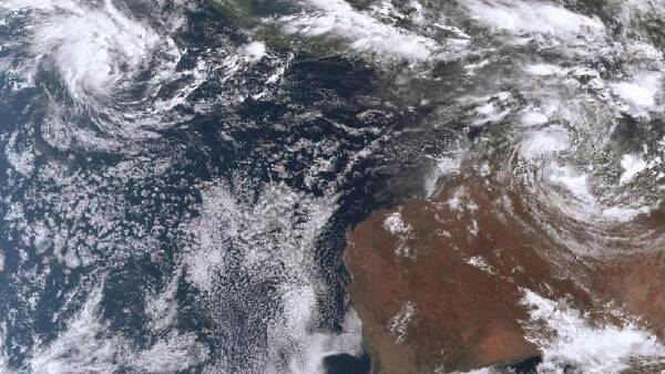
Another cyclone threat is looming, with rain set to lash flood-hit regions for days. Tropical Cyclone Anggrek has formed 500km off the Cocos Islands in the Indian Ocean and is expected to gain strength as it approaches Australian waters this week. The system is set to become a category two cyclone by Wednesday. A cyclone watch has been issued for the Cocos Islands, about 4000km off Western Australia's coast, with gusts up to 120km/h expected. It will mark the second cyclone off Australia this season following Jasper's devastating impact on far north Queensland last month. Weeks after being hit by record flooding caused by Jasper, another cyclone threat is emerging in the far north. A tropical low has developed off Cairns and is a "high" chance of developing into a tropical cyclone by Sunday before strengthening further. "There is a chance that the system will develop into a severe tropical cyclone early next week," the Bureau of Meteorology website said. The low is set to track away from the Queensland coast this week. But it might start moving back toward the far north next week after becoming a cyclone. "There are indications that it could start to track back towards the coast but we are still looking well beyond seven days ahead," a bureau spokesman told AAP. Showers still plague the region as it recovers from floods, with widespread falls of more than 100mm recorded across much of tropical northern Australia. More rain is forecast with a flood watch current for Cape York and parts of the Gulf of Carpentaria. Another rebuilding region - Queensland's southeast - has also been drenched with falls of more than 100mm, with three people rescued from their car amid flash flooding on the Sunshine Coast overnight. The southeast is still recovering after seven people died in storm-related incidents over the Christmas period with about 130,000 homes losing power at one stage. Flood warnings have also been issued for the Northern Territory as another tropical low lingers. The Top End's northwest corner copped widespread 100mm falls and strong winds with the Adelaide River south of Darwin recording 140mm overnight. The tropical low off the NT is set to shift south and head inland in coming days, with no cyclone threat imminent. There is a severe weather warning current for heavy rainfall and damaging winds of up to 90km/h for the NT's northwest. Scattered six-hourly rainfall totals between 100mm and 160mm are likely for the area. There was plenty more rain around, with a band of storms stretching from southern inland NSW and across central South Australia. In the past 24 hours, there have been severe thunderstorms at Mount Gambier, SA, as well as across northern NSW and southeast Queensland. The most significant storm activity on Tuesday was through southern parts of NSW and Victoria's northwest. Showers and storms were expected late on Tuesday for much of South Australia up to eastern NSW and Queensland's southeast. Australian Associated Press


